


rando champ du feu

bendoush
User
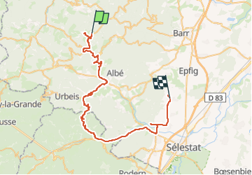

Length
60 km

Max alt
1109 m

Uphill gradient
911 m
Km-Effort
75 km

Min alt
179 m

Downhill gradient
1764 m
Boucle
No
Creation date :
2025-06-14 12:19:49.031
Updated on :
2025-06-14 15:16:12.809
2h55
Difficulty : Very easy

FREE GPS app for hiking
 SityTrail
IGN / Geographical institutes
SityTrail Plus
The world is yours!
About
Trail Walking of 60 km to be discovered at Grand Est, Bas-Rhin, Le Hohwald. This trail is proposed by bendoush.
Positioning
Country:
France
Region :
Grand Est
Department/Province :
Bas-Rhin
Municipality :
Le Hohwald
Location:
Unknown
Start:(Dec)
Start:(UTM)
372245 ; 5363075 (32U) N.
Comments